Sunday, August 29, 2010

Shiretoko Peninsula

Protruding out of the northeastern end of Hokkaido, Shiretoko Peninsula is truly one of the most remote and untouched parts of Japan. In fact, in the Ainu language, Shiretoko means "the end of the earth"! It is recognised as a UNESCO World Heritage Site (as recent as 2005) and cutting into the Sea of Okhotsk, it is the most southerly point where sea ice will form. (I've covered an ice-breaking cruise in the Sea of Okhotsk in my post on Abashiri).


The best way to access the area is really to drive. Even then, most part of the peninsula is not covered by roads (or is restricted access) and there are only 2 towns close/within the peninsula - Utoro and Rausu. Buses to these towns however, operate only in non-winter months, and is really expensive I feel! I took the JR train to Shari town, where I transfered to the bus to Utoro and subsequently, another bus to Iwaobetsu Youth Hostel where I stayed. Iwaobetsu Youth Hostel is well covered in the various guidebooks and is really a great place to get close to nature. The highlight for me there however, is really the salmon dinner in which a whole salmon is prepared in front of the diners and made into 5-6 different delicious dishes! Phenomenal!


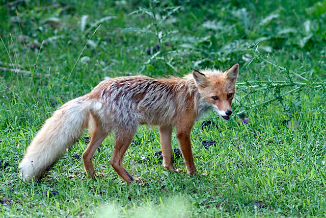
The beauty of the place, of course, is the nature. Large portion of the peninsula is designated as Shiretoko National Park and hence access to a number of areas are limited/restricted. However, there are still plenty of activities available - a trek up Mt Rausu, an easy boardwalk/trail to the Shiretoko Five Lakes, a number of waterfalls and an impressive visitor centre. You could also take a cruise from Utoro and go whale or seal spotting! When I was there, access to 3 of the 5 lakes was closed as bear activity was spotted!! Sika deers, however, is common and easily spotted. But my contact with nature was the most magical when I managed to spot the red fox! Imagine my thrill!

For nature lovers, Shiretoko Peninsula and Shiretoko National Park is definitely a must-go when you next visit Hokkaido!

Sunday, August 22, 2010

Rebun Island, Hokkaido

Rebunto or Rebun Island, lies just off Hokkaido's northern tip and forms part of the Rishiri-Rebun-Sarobetsu National Park. As it is quite literally the most northern part of Japan, it requires some getting to, and so not that many visitors come to the island. But for those that do, it is mainly for two reasons, it's flora and the many hiking options.


During the summer months of June to August, Rebunto burst into bloom and that's where visitors start flocking to the island. The island hosts some alpine flowers which are supposedly found nowhere else! There are also a good selection of hiking options, as well as acommodation options on the island, all of which can be found right in the ferry terminal (most is in Japanese, but there are some English information to get by).

Unfortunately, I went on a hiking trail (the 4-hour course) that features more of the coastal scenery than the flowers, so I did not get to see many of the famed flora. Nevertheless, it was a great walk with great views, and I really enjoyed it. And the trail ended right at the northern tip of the island, where there is a minshuku (a homestay) which claims to be the northernmost minshuku in Japan! (no, I didn't stay there)


Access to Rebunto (and Rishirito) is via Heartland Ferry from Wakkanai. There are limited express trains and buses to Wakkanai from Sapporo. It is possible to get from Sapporo to Rebunto in a day, but you have to get the earliest train noting the ferry schedule. If you are a hiking and flower fan visiting Hokkaido in Japan, do check out Rebun island!

Saturday, August 14, 2010

Rice Paddy Field Art

In the small village of Inakadate, just half an hour from Hirosaki town in Aomori Japan, a work of art is being "grown" every year. While not in any English guidebooks I've seen, it attracts hundreds of thousands of local tourists each year.


Unlike crop circles where areas of the crop are being bent or tamped down, the art on the rice paddy fields of Inakadate uses "creation" vs "destruction". With planning, precision and patience, the art is literally being grown. Made up of 3 different types of rice (technically 4, including the green canvas), the rice are planted in May (with a festival I believe), and up until harvest time in September, the farmers of Inakadate can witness the growth of their field art. I visited in early August, and as you can see, the art is already fully visible. Every year, a different art is used, from samurai warriors to Mona Lisa portraits. The art fields can be viewed from the top of a mock castle tower that is part of the village office building.

For non Japanese speaking independent tourists, getting to the viewing tower may be alittle challenging. There is a Inakadate train station (on the Konan Rail line) which you can take to from Hirosaki station. From the small abandoned-looking Inakadate station, turn left onto the road as you exit the station and walk towards an intersection where there is a K-circle convenience store. From there, it's a straight 40min walk to reach the art fields. Along the way, I found that there is a bus from Hirosaki that stops just 5min from the site, so you may want to enquire about that in Hirosaki.


The rice paddy field art has grown over the years since it started in 1993, and the art has grown more complicated every year. They now use computers to help plot the art, and they've also started educating officials from other parts of Japan. In fact, I believe this year there is such a rice field art on display in Asahikawa in Hokkaido!

From what little info I gather from the internet, it was gratifying to be able to see these art in person. When you do pass by Aomori next time, do check out what art is on display on the Inakadate rice fields!