Friday, December 31, 2010

2010 in pictures

Last post of 2010!
Here's a collage of a selection of photos of my ongoing trip started in Sep 2010!

Happy New Year Everyone!!

Sunday, December 26, 2010

Český Krumlov

Český Krumlov, a town in the Bohemian region of the Czech Republic, and also a UNESCO World Heritage Site, is definitely a destination worth stopping a couple of days for, especially if you are traveling in winter.


From the bus terminal, as you walked to the old town in Český Krumlov, you will walk over a hill overlooking it, and the view you get is like a page off a fantasy story book. Draped in white, over a mixture of architecture styles (Baroque, Renaissance etc), the scene is postcard perfect. In winter, Český Krumlov is arguably the prettiest town in the Czech Republic. Despite its touristic popularity, Český Krumlov has a charming, easy-going and laidback feel about it.


Within the old town, the narrow cobblestone streets coupled with various cafes, art galleries, exhibits and cute little shops makes for a really enjoyable stroll around town. And lording above everything else, the Český Krumlov Castle watches over the town. Climbing the castle tower (you need a ticket though) yields a birds eye view of the surrounds, and on a good day, it provides an extremely pictureque panoramic. As for accommodation, pretty pensions are scattered all over town and would be the recommended option if you are not alone. Of course, hostels are available too for the independent traveler.


Just 3-4 hrs by bus from Prague, it is a convenient and recommended stop in the Czech itinerary. Especially in winter!

Sunday, November 21, 2010

Kilpisjärvi

Nestled in the northwestern corner of Lapland Finland, Kilpisjärvi is a village some 350+km above the Arctic Circle (GPS 69°02'N - 20°47'E). With only 120 inhabitants, it is truly a village quite off-the-beaten-path.


Two of the main attractions of Kilpisjärvi is Kilpisjärvi Lake and Saana Fell, a mountain great for hiking. It is also close to the border of both Sweden and Norway, and so there is actually a point where all borders of the three countries meet. A stone marks the exact location (which is on an actificial island) but as I went in early winter, there was no public transportation there and it was too expensive for me to hire a taxi myself. I didn't hike up Saana as well as there was too much snow and so, special equipment is needed.


However, I went there during this period because Kilpisjärvi boasts one of the highest sightings of Northern lights in Finland! Unfortunately, the 2 days/nights I was there, it was cloudy and I did not managed to see the Aurora :(. But the winter sceneries there were absolutely beautiful and made the trip worthwhile.


I did managed to go across over to Norway to the village of Skibotn, close to the shores of the Arctic Ocean. In summer, with the availability of bus transportation, it is possible to go all the way up to Tromso even!

From Helsinki, train travel can only reach as far north as Kolari. From Kolari, you will have to take a bus to Kilpisjärvi (in winter, you have to change bus in Muonio). Another alternative is train travel from Helsinki to Rovaniemi, where you will have slightly more bus options straight to Kilpisjärvi. If you do decide to take the train both ways, it is recommended to get the Finland 3-day railpass. It is cheaper than the 2 separate tickets between Helsinki and Rovaniemi!

For more information, check out the village website.

Sunday, October 17, 2010

Europe-Asia Continental Divide

Border crossing is an integral part of travel when you move from country to country. And on many land border crossing, it is an adventure itself eg. Kunjerab Pass between Pakistan and China (check out my article here)! However, along the Trans-Siberian Rail, you will not cross countries, but cross continents instead!


This is one of the attractions of Yekaterinburg (or Ekaterinburg), the city close to the Ural mountains in Russia where Europe meets Asia. A monument is placed to mark the site, and visitors often come here to have one foot in Europe and one foot in Asia! Some years ago, the authorities in Yekaterinburg decided that a new marker to be built and placed at a site nearer the city, more convenient for travelers to visit! According to the Lonely Planet guide, scientists have agreed that the new site is a more geographical accurate location for the continental rendezvous! An obelisk was unveiled in 2004, and it is constructed from stones from both continents - one stone was taken from the furthest point of the European part, Cape Rock; another was taken from the furthest point of the Asian part, Cape of Deghnev.

New border marker


Gimmick or not, the pull of being standing between 2 continents is strong. There are many "package tours" from hotels and travel agencies in the city that covers the Europe-Asia border site as well as various attractions in the city. You can also hire a taxi to go to the site, which is what I did. The driver also brought me to the old site where the old monument still stands. From my geotagged photos, you will see where Europe supposedly meets Asia (in Russia at least!)

Friday, October 15, 2010

Blog Action Day 2010 - Water

Last year, I participated in Blog Action Day 2009 and blogged about glaciers.
This year, I am in a middle of a long trip and so, will not be blogging about the themed topic. However, I hope this entry serves to remind my readers that the event is still going on and that you can support it too!

Check it out! Thanks!


Change.org|Start Petition

Sunday, October 3, 2010

Tomsk, Siberia

Tomsk may not ring a bell for quite a few Trans-Siberian travellers, and it is a pity. While not on the main Trans-Siberian line, it is a simple "detour" well worth doing, esp in autumn when the city is graced by the autumn foliage.


Billed as a university city, it hosts quite a few of these academic institutions. But interestingly, its main attraction is its 'wooden-lace' architecture - old timber houses that decorate various parts of the city. Some of these have been restored, but a number of them seems to be rooted in the past and amazingly, a couple of them seems to be inhabited as well. However, the city exude a young and vibrant feel (thanks to the universities?), and the streets are lined with cafes with Wifi etc.


What I like about Tomsk though, is how the city is planned out. Aside from monuments and statues found in almost any other Russian city, many parts of the streets are tree-lined, and even part of the tram line goes through a canopy of trees! Strolling seems to be the city's main pasttime, and I think Tomsk is the city I've seen with the most number of couples and families pushing baby strollers!! Furthermore, the Tom river is just besides the main street, and provides another venue for a wonderful stroll! To top it off, in end September, the autumn foliage makes the whole experience even sweeter!


And really, after hours and/or days of eating and sleeping on a train, a brief stay in Tomsk does wonders to your soul...

Monday, September 13, 2010

Roving Random Ramblings

Hi all,
I have embarked on a long trip, and so have started another blog to share some of my thoughts on my journey.
As such, this blog will not be updated as frequently. In the meantime, check out my

Roving Random Ramblings

Thanks!

Sunday, September 5, 2010

Flora Furano

Furano in Hokkaido is well known for its lavender blooms, and as part of my summer Japan trip, I made my way to Nakafurano (one of the municipalities of Furano) in the hope of catching this purple phenomena.


However, while the blooms are still visible in late July, it was past its peak; thankfully, the fields of Furano are still a burst of colour. And accompaning these flowers, the butterflies are happily fluttering, so it was macro photography galore! Furano is a popular Hokkaido (and not just in summer; it's famous for winter skiing as well) attraction, so there're plenty of information available.

But if you're there for the blooms (you should!), then here's document that lists the typical flowering period that could help with your planning. And the takeaway is - it's not just the lavenders that is stunning, there're a whole lot more flower blooms you can catch! Note that the link in the document no longer works, and that as with nature, these are just typical timings, and each year may be slightly different. You can down it here.


In the meantime, here's just sharing a mini gallery of Flora Furano!


Sunday, August 29, 2010

Shiretoko Peninsula

Protruding out of the northeastern end of Hokkaido, Shiretoko Peninsula is truly one of the most remote and untouched parts of Japan. In fact, in the Ainu language, Shiretoko means "the end of the earth"! It is recognised as a UNESCO World Heritage Site (as recent as 2005) and cutting into the Sea of Okhotsk, it is the most southerly point where sea ice will form. (I've covered an ice-breaking cruise in the Sea of Okhotsk in my post on Abashiri).


The best way to access the area is really to drive. Even then, most part of the peninsula is not covered by roads (or is restricted access) and there are only 2 towns close/within the peninsula - Utoro and Rausu. Buses to these towns however, operate only in non-winter months, and is really expensive I feel! I took the JR train to Shari town, where I transfered to the bus to Utoro and subsequently, another bus to Iwaobetsu Youth Hostel where I stayed. Iwaobetsu Youth Hostel is well covered in the various guidebooks and is really a great place to get close to nature. The highlight for me there however, is really the salmon dinner in which a whole salmon is prepared in front of the diners and made into 5-6 different delicious dishes! Phenomenal!


The beauty of the place, of course, is the nature. Large portion of the peninsula is designated as Shiretoko National Park and hence access to a number of areas are limited/restricted. However, there are still plenty of activities available - a trek up Mt Rausu, an easy boardwalk/trail to the Shiretoko Five Lakes, a number of waterfalls and an impressive visitor centre. You could also take a cruise from Utoro and go whale or seal spotting! When I was there, access to 3 of the 5 lakes was closed as bear activity was spotted!! Sika deers, however, is common and easily spotted. But my contact with nature was the most magical when I managed to spot the red fox! Imagine my thrill!

For nature lovers, Shiretoko Peninsula and Shiretoko National Park is definitely a must-go when you next visit Hokkaido!

Sunday, August 22, 2010

Rebun Island, Hokkaido

Rebunto or Rebun Island, lies just off Hokkaido's northern tip and forms part of the Rishiri-Rebun-Sarobetsu National Park. As it is quite literally the most northern part of Japan, it requires some getting to, and so not that many visitors come to the island. But for those that do, it is mainly for two reasons, it's flora and the many hiking options.


During the summer months of June to August, Rebunto burst into bloom and that's where visitors start flocking to the island. The island hosts some alpine flowers which are supposedly found nowhere else! There are also a good selection of hiking options, as well as acommodation options on the island, all of which can be found right in the ferry terminal (most is in Japanese, but there are some English information to get by).

Unfortunately, I went on a hiking trail (the 4-hour course) that features more of the coastal scenery than the flowers, so I did not get to see many of the famed flora. Nevertheless, it was a great walk with great views, and I really enjoyed it. And the trail ended right at the northern tip of the island, where there is a minshuku (a homestay) which claims to be the northernmost minshuku in Japan! (no, I didn't stay there)


Access to Rebunto (and Rishirito) is via Heartland Ferry from Wakkanai. There are limited express trains and buses to Wakkanai from Sapporo. It is possible to get from Sapporo to Rebunto in a day, but you have to get the earliest train noting the ferry schedule. If you are a hiking and flower fan visiting Hokkaido in Japan, do check out Rebun island!

Saturday, August 14, 2010

Rice Paddy Field Art

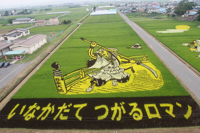
In the small village of Inakadate, just half an hour from Hirosaki town in Aomori Japan, a work of art is being "grown" every year. While not in any English guidebooks I've seen, it attracts hundreds of thousands of local tourists each year.


Unlike crop circles where areas of the crop are being bent or tamped down, the art on the rice paddy fields of Inakadate uses "creation" vs "destruction". With planning, precision and patience, the art is literally being grown. Made up of 3 different types of rice (technically 4, including the green canvas), the rice are planted in May (with a festival I believe), and up until harvest time in September, the farmers of Inakadate can witness the growth of their field art. I visited in early August, and as you can see, the art is already fully visible. Every year, a different art is used, from samurai warriors to Mona Lisa portraits. The art fields can be viewed from the top of a mock castle tower that is part of the village office building.

For non Japanese speaking independent tourists, getting to the viewing tower may be alittle challenging. There is a Inakadate train station (on the Konan Rail line) which you can take to from Hirosaki station. From the small abandoned-looking Inakadate station, turn left onto the road as you exit the station and walk towards an intersection where there is a K-circle convenience store. From there, it's a straight 40min walk to reach the art fields. Along the way, I found that there is a bus from Hirosaki that stops just 5min from the site, so you may want to enquire about that in Hirosaki.


The rice paddy field art has grown over the years since it started in 1993, and the art has grown more complicated every year. They now use computers to help plot the art, and they've also started educating officials from other parts of Japan. In fact, I believe this year there is such a rice field art on display in Asahikawa in Hokkaido!

From what little info I gather from the internet, it was gratifying to be able to see these art in person. When you do pass by Aomori next time, do check out what art is on display on the Inakadate rice fields!

Saturday, July 17, 2010

Unwind @ Sagada

Sagada, a mountain retreat in the Mountain province of the Philippines, has such allure that I enjoy it here more than either Banaue or Batad. Perhaps without the UNESCO status, it is less visited as compared to Banaue, but it still has its fair share of tourism, esp from Manila Filipinos. Yet, it has managed to retain its laidback charm, and amazingly, its affordability.


Although famous for its hanging coffins, Sagada has more to offer. The coffins in the burial caves are also interesting, and many people also come to Sagada to see the limestone caves. The walks and treks around town are fabulous, especially the trek to Mt Kiltepan, where you'll get stupendous views of the valley. Sagada offers varied sceneries that is just so pretty - the rice terraces are not just on the mountains sides, but also carpeted on the valley floors. Pine trees and streams decorate the landscape and there are waterfalls too to complete a day's outing.


While the food is standard Filipino fare, the accommodation options in Sagada are argueably one of the cheapest I've encountered. A room with private bathroom/toilet facilities AND cable TV can be had for 250 pesos (US$6)!! And the best part of it all, for a relaxing peaceful getaway? There was no touting what-so-ever! The 3 days I was there, I was never hassled for anything!


Sagada is covered in the standard guidebooks, but I find this particular site specially useful. When you next visit the Luzon in the Philippines, do check out Sagada!